
|
FAA INFORMATION EFFECTIVE 05 JANUARY 2017
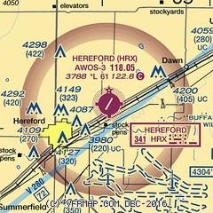
FAA Identifier: HRX Lat/Long: 34-51-38.4304N / 102-19-33.2372W 34-51.640507N / 102-19.553953W 34.8606751 / -102.3258992 (estimated) Elevation: 3787.6 ft. / 1154.5 m (surveyed) Variation: 09E (1995) From city: 4 miles NE of HEREFORD, TX Time zone: UTC -6 (UTC -5 during Daylight Saving Time) Zip code: 79045 |
Airport Operations
Airport use: Open to the public Activation date: 08/1958 Sectional chart: ALBUQUERQUE Control tower: no ARTCC: ALBUQUERQUE CENTER FSS: FORT WORTH FLIGHT SERVICE STATION [817-541-3474] NOTAMs facility: FTW (NOTAM-D service available) Attendance: 0800-1700 Wind indicator: lighted Segmented circle: yes Lights: ACTVT MIRL RY 02/20 - CTAF. PAPI RYS 02 & 20 OPERATES CONTINOUSLY. Beacon: white-green (lighted land airport) Operates sunset to sunrise. |